Updated on 10/15/24
When Hurricane Katrina hit in 2005, it was devastating. The damage was widespread, and the storm had often taken out all visible means of property identification. There were no houses, no street signs, and in some areas, no streets.
Recently, hurricanes Helene and Milton unleashed unprecedented rainfall, and even tornadoes, around the Southeast, submerging communities and causing untold damage. When power is lost to homes and businesses, and street signs, landmarks and other methods of visually identifying property are washed away, how can emergency personnel and first responders know the location of a property?
After the initial danger has passed, finding those in need and assessing infrastructure damage is critical to restoring safety to a community struck by disaster. Searching areas for people who need shelter, are stranded on rooftops or require special assistance to relocate could be nearly impossible when an address becomes virtually meaningless without our typical geographic network.
Emergency response teams benefit from GIS technology
Technology has progressed since Hurricane Katrina struck, delivering new tools and options for emergency responders, insurance claims adjusters and others needing a property’s location or ownership information while on a site. With advancements in GIS technology, coordinating response teams and locating specific addresses is no longer dependent on street signs, roads and landmarks. (Read: Disaster Planning, Management and Recovery with GIS Data.)
ReportAll Feature Service: Identifying properties via ArcGIS® products

ReportAll Feature Service is the essential Esri-compatible parcel data service, bringing our best-in-class data into ArcGIS® Pro, ArcGIS® Online and ArcGIS® Earth. With up-to-date property data essential for recovery efforts, ReportAll Feature Service uses our comprehensive and reliable data, which is updated and transformed daily. At least 90% of properties have been updated in the last 12 months and 70% within 6 months.
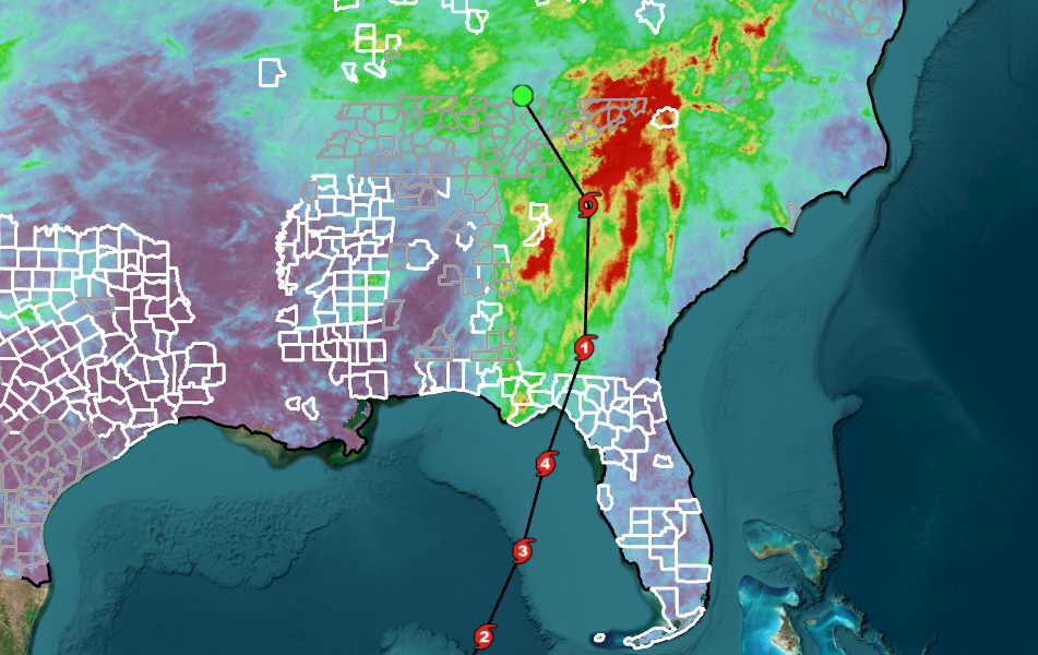
Our most recent data updates include counties in the Southeast that were updated within the last 30 days (gray) and the last 15 days (white), giving responders, and anyone else who needs to know the location of a property, confidence that the most accurate information is available.
For any agency, organization or public utility using GIS technology to locate and assess properties after a natural disaster, the ReportAll Feature Service provides dozens of attributes per parcel, including parcel boundary lines, owner information, a link to the county assessor’s site and more, which can help aid in recovery efforts. Learn more about our Feature Service, which offers a free 30-day trial.
Interactive ArcGIS® map of Hurricane Helene’s path with ReportAll’s updated counties (white = last 15 days; gray = last 30 days as of Oct. 4, 2024)
LandGlide®: On-the-go GIS tool to help identify properties
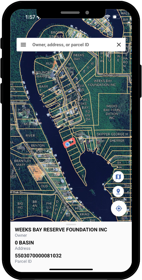
LandGlide is ReportAll’s mobile app, which combines GPS capabilities in mobile devices with our nationwide parcel database. It displays parcel property lines, property address, property owner information and other parcel data while at a location where all visible landmarks have been rendered non-identifiable.
LandGlide can help expedite the process for any in-the-field government agency or business where knowing an exact property’s boundary or ownership information is required. In the weeks after a disaster, LandGlide can be a crucial tool for insurance claims adjusters, construction professionals and local government.
Download LandGlide by visiting the Apple App Store, Google Play or LandGlide.com. Available for a 7-day free trial.