How do you find the commercial property everyone is seeking?
Acquiring prime commercial real estate where none is available.
Location, location, location – it’s no secret but it’s very hard to achieve. By using the latest digital tools, economic development teams and real estate professionals gain a competitive edge.
Commercial Real Estate Developers Look at Same Basic Site Requirements
Here’s the scenario: a national (or international) business is expanding and looking for real estate which fits specific criteria in a highly desirable area. Chances are, so are their competitors. Everyone is looking at population density, average income, property size, zoning restrictions, freeway access, etc. There is also a minimum footprint necessary within an area which fits the criteria above.
In prime locations, the amount of land required isn’t readily available. Plus, from an economic development perspective, the clock is always running as multiple cities vie for development.
Developing Commercial Land for Retail Could Mean Acquiring Multiple Parcels
Finding a lot with enough acreage for retail strip malls, groceries and big box stores in an urban area usually requires assembling individual parcels to meet a required footprint. In this case identifying bordering parcels and contacting current property owners can be time-consuming.
What if you could see parcel property boundaries, owner information and land use, all overlaid on the familiar Google Earth online map – instantly for over 97% of the U.S.? ReportAll’s PARLAY is the key.
PARLAY: Parcel Layer over Google Earth Shows Property Lines & Owner Information
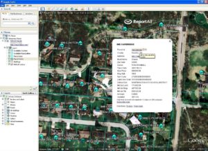
PARLAY is a parcel data overlay for Google Earth showing property lines, parcel boundaries, ownership information and real estate parcel attribute data. View satellite images of areas which fit the location criteria you need and instantly see parcel boundaries to determine which can be combined to create your essential footprint.
Ownership information is provided for each parcel. This speeds the process of contacting landowners and determining their interest in the possible sale of their property. PARLAY’s database is continually updated to keep pace with ownership changes on a national scale.
Take advantage of PARLAY’s 14 day free trial to see if this tool gives you the competitive edge you need!