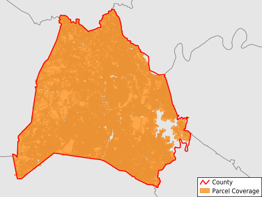
Davidson County
Parcel Data
Price: $250.00
Last Updated:
2024-Q3
Parcels in County:
279,505
Parcel data available to download as a GDB, GeoPackage, Shapefile, Excel, CSV, or Google Earth KML file.
All purchased data comes with six months of access, including any updates, at no additional cost.
Key attribute coverage for Davidson County
The percentage of Davidson County parcels containing the following key attributes:
Owner: 100%
Parcel Number: 100%
Acreage (Calculated): 100%
Site Address: 100%
Mailing Address: 100%
All available attributes in Davidson County
Parcel Number
Site Address
Owner
Sale Price
Land Use Code
Land Use Class
Acreage (deeded)
Acreage (calculated)
Perimeter
Municipality
School District
Zip Code
Flood Zone
Flood Zone Subtype
Census Tract
Census Block Group
Census Block
Total Market Value
Land Market Value
Building Market Value
Mail Address1
Mail Address3
Legal Desc1
Buildings
Addr Sec Unit Num
Place Gnis Code
Land Cover
Elevation
Owner Occupied
Robust Id
Usps Residential
Alt Id 1
Crop Cover
Acreage Adjacent With Sameowner
Municipalities Respresented in Davidson County
District 2: 9,124
District 20: 9,289
District 30: 4,476
District 31: 11,181
District 32: 5,818
District 33: 12,104
District 34: 7,920
District 35: 8,616
District 4: 8,225
District 21: 9,205
District 22: 8,572
District 23: 6,880
District 24: 9,044
District 25: 9,083
District 26: 6,211
District 27: 4,795
District 28: 5,399
District 29: 6,707
District 3: 8,892
District 1: 9,005
District 10: 6,996
District 11: 9,806
District 12: 8,270
District 13: 5,706
District 14: 6,793
District 15: 8,537
District 16: 6,189
District 17: 10,543
District 18: 4,716
District 19: 11,145
District 5: 8,825
District 6: 7,618
District 7: 9,618
District 8: 7,381
District 9: 6,816
Save money when you buy data in bulk
We offer discounted pricing on county and state downloads.