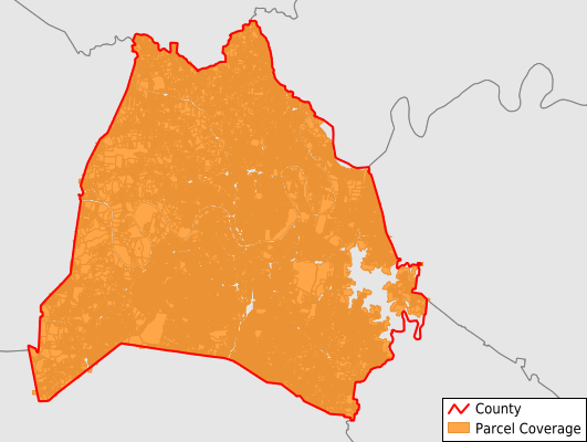
Davidson County
Parcel Data
Price: $250.00
Last Updated:
2026-Q2
Parcels in County:
286,470
Parcel data available to download as a GDB, GeoPackage, Shapefile, Excel, CSV, or Google Earth KML file.
All purchased data comes with six months of access, including any updates, at no additional cost.
Key attribute coverage for Davidson County
The percentage of Davidson County parcels containing the following key attributes:
Owner: 100%
Parcel Number: 100%
Acreage (Calculated): 100%
Site Address: 100%
Mailing Address: 100%
All available attributes in Davidson County
Parcel Number
Site Address
Owner
Sale Price
Land Use Code
Land Use Class
Acreage (deeded)
Acreage (calculated)
Perimeter
Municipality
School District
Zip Code
Flood Zone
Flood Zone Subtype
Census Tract
Census Block Group
Census Block
Total Market Value
Land Market Value
Building Market Value
Mail Address1
Mail Address3
Legal Desc1
Buildings
Addr Sec Unit Num
Place Gnis Code
Land Cover
Elevation
Owner Occupied
Robust Id
Usps Residential
Alt Id 1
Crop Cover
Acreage Adjacent With Sameowner
Flood Zones
Nearest Transmission Line Dist Ft
Nearest Substation Dist Ft
Derived Geom Properties
Robust Id Source
Municipalities Respresented in Davidson County
District 2: 9,860
District 20: 9,495
District 30: 4,501
District 31: 11,560
District 32: 5,883
District 33: 12,410
District 34: 7,922
District 35: 8,771
District 4: 8,428
District 21: 9,425
District 22: 8,595
District 23: 6,891
District 24: 9,200
District 25: 9,158
District 26: 6,253
District 27: 4,839
District 28: 5,465
District 29: 6,737
District 3: 9,077
District 1: 9,105
District 10: 7,316
District 11: 9,996
District 12: 8,412
District 13: 5,710
District 14: 6,946
District 15: 8,627
District 16: 6,207
District 17: 10,763
District 18: 4,732
District 19: 12,657
District 5: 9,179
District 6: 7,788
District 7: 9,712
District 8: 7,877
District 9: 6,958
Save money when you buy data in bulk
We offer discounted pricing on county and state downloads.