Real Estate Portal USA announces that their highly successful LandGlide App is now available for both Android and Apple devices
Real Estate Portal USA (REP), a leading provider in Web-based real estate information for searching and mapping property parcels, announced today the availability of LandGlide for Android devices, complementing their highly successful iPhone and iPad LandGlide version.
“With thousands of active users, LandGlide constantly falls into the top ten business applications in the Apple App Store. LandGlide for Android builds on the same great features as the Apple version with increased functionality. We have taken what we have learned from the Apple version and added new features that users have requested. Topo maps, a streamlined user interface and more billing options are now part of LandGlide for Android. We are currently working to add these great new features to the Apple version for a future no-cost upgrade to our customers,” stated Robert McGee, a founding partner at REP.
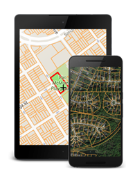
Both versions of LandGlide allow users to explore maps and aerial photos of the US with overlaid parcel boundaries on mobile devices and tablets. Hovering over a property shows the boundaries, parcel identifier, site address, ownership and other property information where available. Users may view and search over 141 million parcel records covering over 95.8% of the U.S. population. Cellular data access is supported, enabling full use while in the field. With GPS-enabled devices, LandGlide provides real-time location-based intelligence.
“Users love the portability of LandGlide. Businesses and individuals use LandGlide to determine a property’s location, address, ownership information and other characteristics while on the road. LandGlide is particularly helpful where clear boundary delineation is not easily determined. By overlaying the property boundaries with the aerial photo, the user will instantly see where one property ends and another begins. LandGlide will help any person or business identify a property’s boundary and associated attributes instantly. LandGlide has become an important tool for the real estate, energy, hunting, and forestry communities,” stated Robert.
LandGlide for Android joins a growing list of innovative products and delivery methods offered by REP. LandGlide for Android is available now through the Google Play Store (https://play.google.com/store/apps/details?id=com.reportallusa.landglide&referrer=utm_source%3Dprweb%26utm_medium%3Dpress_release) with a 30-day free trial and $9.99 monthly or $99.99 yearly subscription options. LandGlide for Apple devices continues to be available through the Apple App Store (https://itunes.apple.com/us/app/landglide/id560902465?mt=8&ct=prweb_press_release ) with a 30 day free trial and $9.99 monthly. Parcel data is also accessible for search and browsing through the company’s website or by subscribing to Real Estate Portal USA’s PARLAY 2.0 parcel layer for Google Earth®. Through the website, subscribers have instant access to available nationwide data, which can be downloaded in shapefile, Microsoft® Excel® or KML formats for easy analysis and visualization in GIS, spreadsheet or Google Earth® software. The company’s fully automated Web store enables subscribers to purchase data and instantly download files 24 hours a day, seven days a week. For more information on purchasing county parcel data or for more product details including sample downloads, visit https://reportallusa.com. For information on API access, custom batches required to meet a specific need, or to inquire about the purchase of the national dataset (https://reportallusa.com/solutions/national-parcels), please send your request to info(at)reportallusa(dot)com.
###
A copy of this press release is also available here on PRWeb.